New Greenground map showcasing city's green spaces revealed with hope of 'inspiring' more Sheffield staycations


So many in fact, that 356 of the 800 total parks, were included in the London Underground-style map, or else it might have been a bit too busy visually, to say the least.
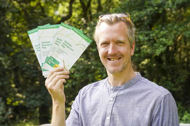
The map commissioned by Sheffield Council was created by artist Helen Ilus and aims to showcase how accessible green spaces are for everyone, everywhere in ‘The Outdoor City.’
Advertisement
Hide AdAdvertisement
Hide AdIt also reveals how the city’s numerous pockets of greenery, many hidden gems and totalling 4,000 hectares in the city boundary, can connect with each other.
The map came about when Helen’s London design, inspired by the iconic Tube map and incidentally featuring fewer parks than Sheffield at 300, was spotted by a city runner.
“This was an interesting coincidence”, Helen, who is now based in Tallinn, Estonia, told the Sheffield Telegraph.
“The London map was recently printed in Runners World and a Sheffield runner liked it so much he got in touch and introduced me to the people behind the Outdoor City project. I didn't think at first this project would take off, but they were immediately interested and asked me to partner up in creating the Sheffield Greenground Map.
Advertisement
Hide AdAdvertisement
Hide Ad"All the other maps I've designed have been independent projects so I am very glad Sheffield Council picked up the torch and decided to lead the way with the very first official Greenground Map”
How did creating Sheffield’s map compare to London’s, which focuses on being a alternative sustainable transport map for the capital?
Helen said Sheffield was the ‘coolest’ city she has worked with, having also created maps for Edinburgh and Bristol since.
She said: "Sheffield is very different from London and though Londoners can be proud of having many parks in number I think Sheffield's strength is having vast areas of natural open space.
Advertisement
Hide AdAdvertisement
Hide Ad"A third of the city is based in Peak District and this offers so many opportunities for recreational activities - from walking, bird watching and forest bathing to serious hiking, mountain biking and professional climbing.. so there's something for everyone and all abilities.
"Sheffield is quite hilly, so I especially like the viewpoints in the parks around the city and the long river walks as Sheffield has plenty of blue space as well.”
Some 22,000 copies of the Greenground map have started to be distributed this week through Sheffield’s parks, independent shops and hospitality venues, libraries, community centres, hotels and the BID shop on Tudor Square.
Plans are being looked at for development of the Greenground concept – such as more detailed versions of certain areas and the possible printing of a poster.
Advertisement
Hide AdAdvertisement
Hide AdIt is also printed for readers inside this week’s Sheffield Telegraph for the launch of our new Park Life entertainment supplement and can be downloaded for free at theoutdoorcity.co.uk.
Helen said she hoped the map would help raise awareness of Sheffield’s potential when it comes to domestic tourism.
She added: “I'm sure all Sheffielders know, in what a beautiful green city they live in, but I think the map also helps visitors to see the city through greener eyes and have more awareness of Sheffield as a significant outdoor destination.
“Local travel is booming this year everywhere and I hope a few people who see this map might be inspired in spending few days in Sheffield. I also hope locals will be encouraged to explore parks out from their usual way and find local gems they didn't know about.
Advertisement
Hide AdAdvertisement
Hide Ad“Absolutely I’d be interested in making a second map if this one proves popular.
“This is still a very experimental project and we could have spend more time making it – but I think it was perfect timing to get it out now, in the peak of the summer, when lots of people are out and needing it most.
"We've had many restrictions recently and people just want to have a good time, spend some time in nature and relax.. so I hope this helps both Sheffielders and visitors to have memorable days out.”
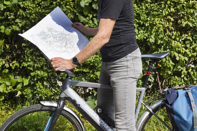
The map draws on rivers, activity and geography themes as key ‘lines’ – as well as featuring the Sheffield Round Walk and Sheffield Greenway Walk. For the more adventurous, it shows where the best spots are for kayaking, bouldering, climbing, birdwatching and biking, as well as key viewpoints of the city and campsites.
Advertisement
Hide AdAdvertisement
Hide AdThe map was made possible with funding from The University of Sheffield, Sheffield Hallam University, Move More and The Sheffield Property Association.
Coun Paul Turpin, the city council’s executive member for inclusive economy, said: “Clearly this map promotes physical activity, exploration, health and sustainable travel. But it’s important to note all those things link back to our economy – if we can show people what a great place Sheffield is to live, and help everyone here lead healthier lives, then it will benefit our businesses and exponentially improve our city.
“The map has also launched just as our Summer in The Outdoor City activity takes off.
"As we hope to see a rise in domestic tourism, we’re making the map available to our key hotels too as this will make a great ‘take home’ memento for many people no doubt surprised at just how much green space there and inspired to come back.”