New Maltby housing development approved, but residents say town is at ‘breaking point’

and live on Freeview channel 276
Applicant Hargreaves Maltby Limited has been granted outline permission to build the homes on land north of Tickhill Road, Maltby, known locally as Highfield Park.
Planning documents state that the site is currently made up of disused allotments, woodland and a former sports field set between Maltby and the former Maltby Colliery.
Advertisement
Hide AdAdvertisement
Hide AdAccess will be taken from Tickhill Road, which has been subject to a road safety audit which has ‘raised no issues’.
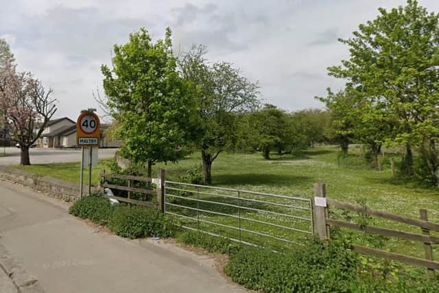

Around 100 allotments will replace existing allotments on a 1.2-ha area of land at the northern end of the site, and the existing public open space will be retained and enhanced.
The current 40mph speed limit on Tickhill Road will be extended to the east of the site access to improve road safety.
The plans were approved by councillors during today’s (November 23) planning meeting, despite opposition from residents, councillors and an MP.
Advertisement
Hide AdAdvertisement
Hide AdJames Gibbs, planning advisor to Hargreaves Land, told the meeting that “the current quality of the open space is poor.
“The site has suffered significant levels of anti-social behaviour, crime and fly-tipping.”
Mr Gibbs added that the development would ‘transform’ the site, with 185 new homes – 25 per cent of which are deemed affordable.
Half of the site would also be retained as open space, and the developers would have to contribute £500 per house towards sustainable travel, £181,557 towards improvements to sports facilities, and £40,000 towards a cycle link between the site and Glencairn Close.
Advertisement
Hide AdAdvertisement
Hide AdA contribution of £2,521 per home would also be required to fund school places for youngsters with special educational needs and disabilities.
Jackie Weaver, who holds an allotment on the site, opposed the plans, and told the meeting that her allotments once belonged to her great-granddad, and had been passed down to her.
“I’ve been on there 58 years,” she told the meeting.
“Since Hargreaves took over, it’s been horrendous. We’ve had fires and all sorts. There’s loads of wildlife about.
“I’m just guttered. I’ve had horses on there for 46 years.”
Councillor Linda Stables spoke on behalf of Maltby Town Council, and told councillors that the town ‘is at breaking point’. She also said there were concerns over coal slag, though work had been done to prevent the heap slipping, as had happened in Aberfan in South Wales in 1966.
Advertisement
Hide AdAdvertisement
Hide Ad“The area….has been a reassuring buffer between the houses and the pit tip. The pit tip’s made up of coal slag, it’s now been dumped with contaminated waste.
“The reassuring buffer has reassured the people of Maltby that we won’t be another Aberfan.
“We’ve got concerns about infrastructure – doctors dentists, school, the road being very busy, it’s an accident blackspot.
“We simply are at breaking point.”
Coun Stables added that schools in the area are oversubscribed, and urged councillors to ‘stand up and say no to this development’.
Advertisement
Hide AdAdvertisement
Hide AdCouncillor Adam Tinsley also opposed the development, and a letter was read out from Rother Valley MP Alexander Stafford, who could not be at the meeting.
His letter read: “I cannot and will not support any development on precious green space in our communities.
“I know the planning officers will say that this land is no longer green space, it is designated for housing.
“However, every local person knows that this land is recreation space. It is parkland. It is woodland. It is for dog walking. It is for children playing. It is for small holdings. It is a barrier between the town and the pit top”.
Advertisement
Hide AdAdvertisement
Hide AdEmma Ottewell, development manager at the council, said that the site had been inspected, and the risk of slippage is ‘low, given the shallow grading of the site’.
Ms Ottewell added that the NHS “accepted that a number of the people who would occupy the houses wouldn’t be new residents…people are moving within the community. Many of them would already be registered at GP surgeries”.
Simon Gammons, Rotherham Metropolitan Borough Council (RMBC) highways development control officer said: “We’ve accepted the fact it’s safe [with] clear visibility in both directions.
“We appreciate there are speeds as you come from the site.”
Planning documents add the NHS Rotherham Clinical Commissioning Grouphas indicated that an increase of approximately 400 residents in this case ‘has the potential to create a pinch point for existing primarycare services’.
“However, although existing services are stretched they will cope better with gradual growth,” adds the report.