Storm Isha Sheffield: Yellow weather warning for winds of up to 50mph in place for next three days

and live on Freeview channel 276
Sheffield faces three days of gale-force winds in the wake of Storm Isha this week with gusts of up to 50mph.
Yellow weather warnings have been issued for the next three days straight for the Steel City and much of the North.

Advertisement
Hide AdAdvertisement
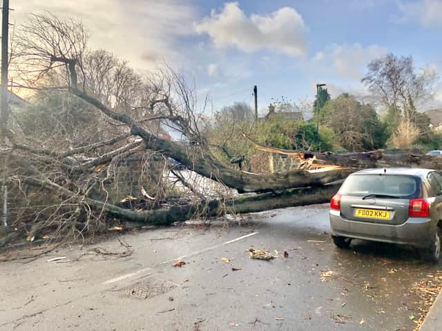
Hide AdIt is a downgrade from the amber warning issued on Sunday but it still carries the risk of damaging buildings and toppling trees.
Even though Storm Isha is set to peel away from the British Isles over the course of Monday, high winds and a heavy band of rain are forecast for the next three days.
Thousands of people are reportedly without power in Northern Ireland and Scotland has been warned that winds could reach of up to 90mph. The Tornado and Storm Research Organisation (TORRO) is warning of the potential for multiple tornadoes in Northern Ireland and Scotland.
What is the weather forecast in Sheffield during Storm Isha (January 22 - 24)?
Here is how Sheffield will be affected day by day during Storm Isha.
Advertisement
Hide AdAdvertisement
Hide AdMonday, January 22: Strong winds will are expected all day ramping up to over 40mph at around 12 noon There may be some damage to properties and trees may come down. Otherwise generally a bright day with sunny spells, with blustery showers in the mid-afternoon. Maximum temperature 8C, but it will feel like 1C by eveningtime.
Tuesday, January 23: Conditions will be much wetter on Tuesday in Sheffield. After a dry and cloudy start, a heavy rain storm will sweep across the Steel City starting at around 9am and will continue to fall pretty much constantly until 5pm. Winds will also gradually pick up over the day, going from a stiff breeze of 21mph in the morning and rising to strong gales of 47mph by 6pm. However, there will be unseasonably warm maximum temperatures of 13C.
Wednesday, January 24: Yellow weather warnings persist into Wednesday. It is currently predicted to be much drier by midweek, but winds are forecast to rise to up to 48mph with maximum temperatures of 10C.
Storm Isha batters UK
High winds forced the closure of the Tay Road Bridge, M48 Severn Bridge and the A66 in Durham and Cumbria between the A1(M) and the M6, while the Humber Bridge, A19 Tees Flyover and A628 Woodhead Pass in Derbyshire were among stretches closed to high-sided vehicles.
Advertisement
Hide AdAdvertisement
Hide AdScotRail services have been suspended since 7pm on Sunday and are not expected to resume until around noon on Monday as dozens of lines are closed due to fallen trees and flooding.
Meanwhile, air traffic control restrictions are in place, leading to flight cancellations and causing many planes to divert.
National Air Traffic Services told the PA news agency: "Due to adverse weather conditions across the UK, temporary air traffic restrictions are in place. Restrictions of this sort are only ever applied to maintain safety.
"Our teams are working closely with airports and airlines to minimise disruption. Passengers should check the status of their flight with their airline."
Advertisement
Hide AdAdvertisement
Hide AdThe Met Office said the highest recorded wind speed during Storm Isha was 99mph at Brizlee Wood in Northumberland, with gusts of 90mph at Capel Curig in Snowdonia on Sunday.
A rare red warning for wind in north-east Scotland was in place until 5am on Monday, with amber warnings covering much of the UK until 6am and further yellow warnings covering the entire country until noon.
The Met Office said "everybody" was affected by the storm.
Heavy downpours battered some places, with 28 flood warnings in place in England and 50 in Scotland.
Comment Guidelines
National World encourages reader discussion on our stories. User feedback, insights and back-and-forth exchanges add a rich layer of context to reporting. Please review our Community Guidelines before commenting.